 eAtlas Data Catalogue
Coastal Waters (Australia)
Type of resources
Topics
Keywords
Contact for the resource
Provided by
Years
Representation types
Update frequencies
status
-
This record provides an overview of the NESP Marine and Coastal Hub small scale scoping study: Marine and Coastal Threatened Species and Communities. There are numerous species and ecological communities in Australia’s marine and coastal environments that have formal threatened conservation status. Through a process of targeted reviews, expert elicitation and workshops with end-users, domain experts and others, this project will identify and co-design prospective research projects that best deliver information that will notably improve the status of key selected threatened species in Australia’s marine and coastal environment. Outputs will include summaries of workshops outcomes and a set of co-designed research proposals for submission in future Hub annual research plans. This project also provides the platform for MAC Hub contributions to the Resilient Landscapes Hub Cross-Hub Mission Project 7.0 on Threatened and Migratory Species and Ecological Communities. Planned Outputs • Final technical report recommendations for policy makers of key findings for priority research areas [written]
-
This record provides an overview of the NESP Marine and Coastal Hub study - Assessing dugong distribution and abundance in the southern Gulf of Carpentaria. For specific data outputs from this project, please see child records associated with this metadata. Aboriginal ranger groups, Traditional Owners of the southern Gulf of Carpentaria (sGoC), scientists, Queensland, Northern Territory and Commonwealth government representatives will co-design and implement a program that enables a contemporary cross-border understanding of dugong populations and other marine megafauna. The dugong program comprises three parts: 1) Dugong population genetics, 2) a standardised aerial survey in the sGoC, and 3) Indigenous-led drone surveys of marine megafauna hotspots. The collaborative approach will enable contemporary data on abundance, distribution and genetic population structuring to inform local and regional conservation management actions. In combination with other NESP investments in Qld and WA, this program will have applied consistent approaches to dugong population assessment across three states. This program directly responds to the national priorities of conserving, protecting and sustainably managing biodiversity through research and information management. Planned Outputs • dugong distribution & abundance [spatial dataset] • Final technical report with analysed data and a short summary of recommendations for policy makers of key findings [written]
-

This record provides an overview of the NESP Marine and Coastal Hub small-scale study - Barriers to using UAVs in conservation and environmental management. Environmental managers are embracing technology to assist with monitoring and evaluating coastal wetlands. Drones are being used routinely for fauna tracking and water sample collection; however, barriers in broader application still remain for adoption in environmental management. This research will survey conservation professionals about the barriers preventing drone adoption. Tools available for conservation and environmental research are becoming more advanced and accessible to scientists, community and managers (Isosevic et al., 2021). The ability to mobilise science and technology has become increasingly more important for governments that are faced with balancing development and protection of the environment (Cash et al., 2003, Waltham and Sheaves, 2015). With the proliferation of UAV usage in research (Shahbazi et al., 2014, Hardin et al., 2019, Tmušić et al., 2020) and innovative ways in which they can be used to collect data, it is important to investigate whether these have a place in the conservation toolbox for conservation management. Managers need data on ecosystems to manage and protect them (Dale et al., 2019, Di Stefano, 2004), therefore the potential advantages of UAVs means that data collection using these tools could be more representative and cost-effective (Joyce et al., 2019). However, current management structures do not always leverage data or innovations effectively (Cash et al., 2003). Planned Outputs • manuscript publication • summary information sheet
-
This record provides an overview of the NESP Marine and Coastal Hub study - Scaling-up long-term seagrass restoration in the Cocos (Keeling) Islands. For specific data outputs from this project, please see child records associated with this metadata. There is an urgent community-driven need to develop appropriate seagrass restoration approaches at scale for the Cocos (Keeling) Islands (CKI). Fast-tracking larger-scale restoration research is required to prevent imminent collapse and functional extinction of seagrasses at CKI due to past disturbance and current green turtle grazing pressure. This project builds on pilot studies to design and establish a network of larger-scale turtle exclusion areas where locally appropriate restoration approaches can be refined. At the same time, this will provide “seagrass refuges” to initiate recovery, monitor ecological effects, and provide for future restoration efforts. The project has been co-developed with the CKI community and Parks Australia, addressing their highest research priority identified in the newly established Cocos (Keeling) Islands Marine Park. The project will provide an action plan for ongoing interventions and strategies to future-proof local seagrasses and support seagrass-dependent species, such as green turtles and fish, in the long term. Planned Outputs • exclusion zones experimental data [spatial & tabular dataset] • environmental monitoring dataset [tabular data] • Final technical report with analysed data and a short summary of recommendations for policy makers of key findings [written]
-
This record provides an overview of the NESP Marine and Coastal Hub small-scale study "A roadmap for coordinated landscape-scale coastal and marine ecosystem restoration". For specific data outputs from this project, please see child records associated with this metadata. This project aims to develop a roadmap to guide research and investment into landscape-scale coastal and marine restoration. The project brings together interdisciplinary expertise in coastal engineering, decision theory, marine ecology, modelling and ecosystem services to examine decision support needs and opportunities to restore coastal marine ecosystems at scale. The research will focus on the ecosystem services of coastal protection and climate resilience with the recognition that this Nature-based Solution (NbS) approach provides co-benefits such as biodiversity, fisheries production, carbon sequestration, and nutrient cycling. The research will be accomplished through surveys and workshops/meetings with input from key end user groups in industry, NGO, Indigenous and Governmental organisations Planned Outputs • Final technical report with analysed data and a short summary of recommendations for policy makers of key findings [written]
-
This record provides an overview of the NESP Marine and Coastal Hub study - Developing Traditional Owner community-led dugong monitoring in the Kimberley region. For specific data outputs from this project, please see child records associated with this metadata. Dugong are a keystone species with considerable ecological and cultural value across northern Australia. In the Kimberley region of Western Australia, dugongs have been identified as one of the top priorities to monitor in an effort to ensure the population is maintained and traditionally harvested in a sustainable manner. This project aims to have Traditional Owners and ranger groups across the Kimberley use cost-effective and culturally appropriate approaches to (1) fill knowledge gaps on the dugong’s population structure and connectivity at a range of spatial and temporal scales and (2) monitor the animals’ presence, density and habitat use in areas that are ecologically and culturally important to the local community and state and federal managers. This program directly addresses the national priorities of conserving, protecting and sustainably managing biodiversity through research and information management. Planned Outputs • dugong distribution and abundance [spatial dataset] • aerial survey outputs [imagery & photogammetry] • genomic sequencing data • code and scripts • Final technical report with analysed data and a short summary of recommendations for policy makers of key findings [written]
-

This record provides an overview of the NESP Marine and Coastal Hub small-scale study - "Protected Places Mission Scoping Study". This project engaged relevant stakeholders, researchers and research providers, including relevant sections in the Department of Climate Change, Energy, the Environment and Water (DCCEEW, previously DAWE) sections to co-design a research plan for the Mission over the 7-year duration of the NESP Hub. The workshops and engagement process developed the Mission focus areas, vision, activities, indicators, and outcomes from the Mission, and identified Mission specific research needs for the near term. Over 35 conversations with 65 people resulted in over 200 ideas. Outputs include a set of priority co-designed project proposals for submission in the subsequent annual research plans of all four Hubs and an overall Strategic Plan for this Mission. Planned Outputs • A detailed research plan on protected place management that identifies the short-term research needs that need to be prioritised and the long term goals that will be met over the 6 years of NESP funding. [written]
-
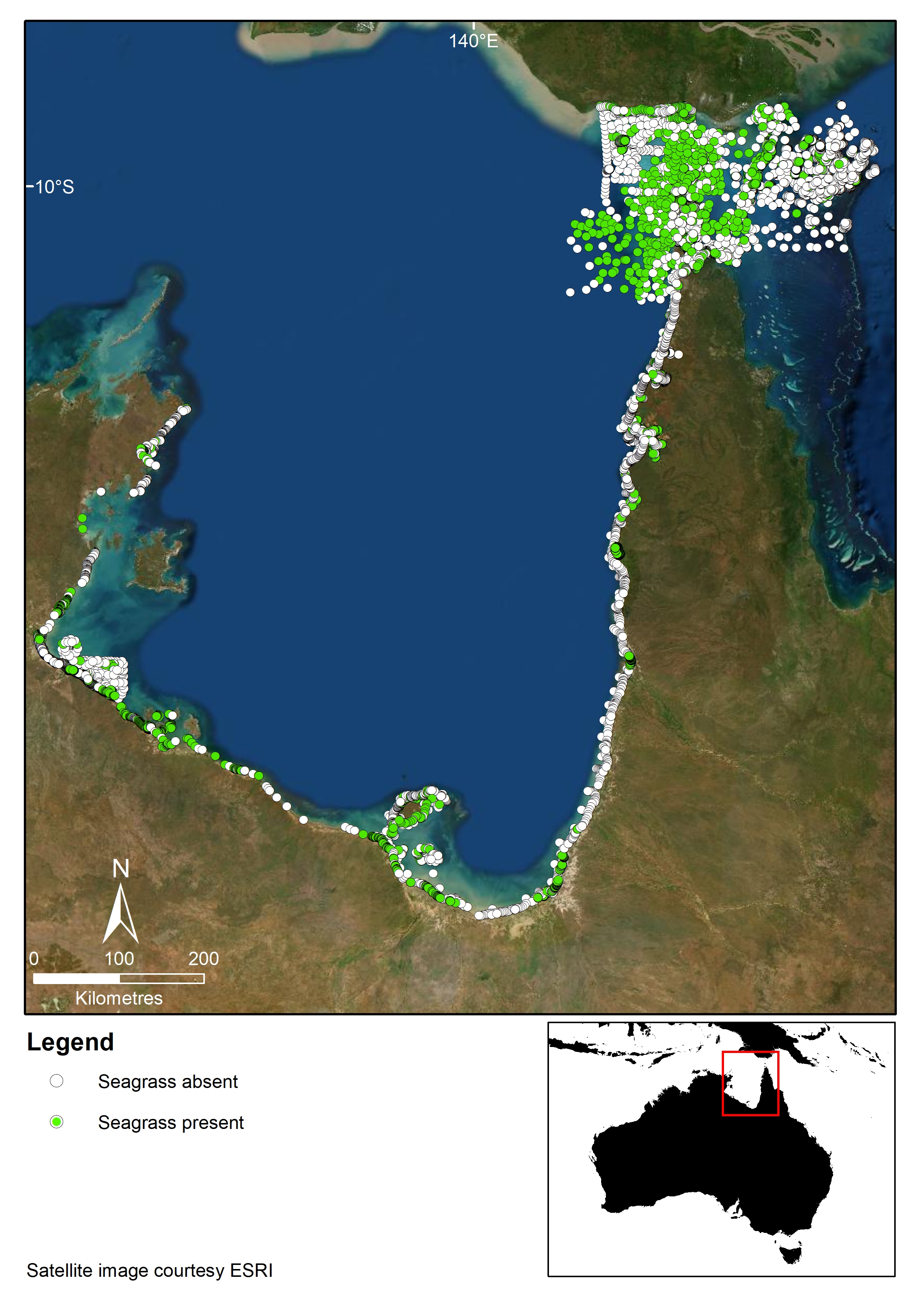
This record provides an overview of the NESP Marine and Coastal Hub small-scale study - "Synthesizing three decades of seagrass spatial data from Torres Strait and Gulf of Carpentaria". For specific data outputs from this project, please see child records associated with this metadata. The Gulf of Carpentaria and Torres Strait have globally significant seagrass habitat that provide food for threatened dugong and turtle, and habitat for commercially important fish and prawns. Key to understanding, managing, mitigating risk, and monitoring seagrass in this remote region is reliable data on seagrass distribution and species composition and how these changes through time. Data on seagrass has been collected in these areas since the 1980s, but data location and storage from these efforts remains disparate, in many cases not publicly available, and in some cases has already been lost. Our study will compile, validate and synthesize historical seagrass spatial data to create a publicly available database accessible on eAtlas. This product will provide end-users with a valuable spatial resource to assist management and monitoring of seagrass in the region. (i) Identify key seagrass habitat and migration corridors for dugong and turtles in the Gulf of Carpentaria and Torres Strait. (ii) Identify regions where seagrass information is deficient (knowledge gaps) (iii) create a foundations for models assessing exposure to risk (water quality and other environmental impacts, climate change, etc) (iv) provide essential information for management, planning, and developing long-term monitoring plans Planned Outputs • seagrass data [spatial dataset] • Final technical report with analysed data and a short summary of recommendations for policy makers of key findings [written]
-

This record provides an overview of the NESP Marine and Coastal Hub small-scale study - "Scoping Study: Indigenous Participation and Research Needs". This scoping study builds on the engagement undertaken during the development of the NESP proposal for the Marine and Coastal Hub, where 42 Traditional Owners and Native Title holders across mostly northern Australia provided support for our bid. This period of engagement identified the need to consult widely with Indigenous leaders and groups before committing to substantive research projects. This scoping study provides the resources to begin such a consultation with Indigenous partners on their aspirations for the Marine and Coastal Hub. It will also provide a vehicle for the Hub to actively engage the NESP Indigenous Facilitators Network. As part of the Australian Government policy on Closing the Gap and consistent with Part 6 of the Northern Australia Indigenous Development Accord, this scoping study will explore how best to execute increased Indigenous ownership over participatory research and how such a program can deliver on the Department’s stated aspirations of meaningful and substantive engagement of Traditional Owners. This scoping study will bring together key Indigenous leaders and groups to plan, prioritise and evaluate potential research directions. Specifically, this scoping study will engage with Indigenous Australians to develop a cohesive set of prospective projects for investment under future Hub research plans, that deliver up to large-scale, broader picture goals for Indigenous people. This will require marshalling of Indigenous knowledge and development and enhancement of Indigenous relationships. Consultation will involve both Indigenous only and Indigenous-researcher meetings and workshops. We are seeking ethical Indigenous engagement, equitable participation and co-design and co-delivery of national environmental research priorities, while substantially increasing the outcomes for social, economic and cultural terms for Indigenous people. Planned Outputs • Final technical report with analysed data and a short summary of recommendations for policy makers of key findings [written]
-
This record provides an overview of the NESP Marine and Coastal Hub project 'Towards assessing the values of reefs in the southern Gulf of Carpentaria 2024 - 2025'. For specific data outputs from this project, please see child records associated with this metadata. The Gulf of Carpentaria Marine Park was only recently declared in 2013. The zoning plan for this marine park, which permits trawling within a specific trawling zone is due for renewal by 2028. There is a strong need to collect, analyse, synthesise and make publicly available information on the values and conditions of key habitats within the Marine Park, such as recently identified patch reefs and coral reefs, to contribute to this upcoming review of the management plan for this marine park. The limited scientific information that is available on the values of this marine park is hard to access and much of it has not been analysed or written up. In addition, the Traditional Owners hold much valuable information about the ecological and cultural values that should inform future park management decisions. This project aims to gather, synthesise and report on existing scientific data and information about coral and patch reefs in the marine park. This information will be presented to the Traditional Owners and other relevant stakeholders at community meetings or workshops. Documenting cultural values of the reefs in this marine park is beyond the scope of the current project and would require considerable further engagement with Traditional Owners. However, it is anticipated that presentation of existing scientific and biophysical data at community meetings will start this process. We will produce visual (e.g. photos and videos) outputs that illustrate the values of these reefs, in order to better inform stakeholders involved in decisions about future park management. Planned Outputs • Final technical report with analysed data and a summary of recommendations for policy makers of key findings [written]